I began at the South East Corner (SE) and am currently working counter-clockwise around the Church.
The
Codes are:
|
Check back daily to see what's old and what's new!
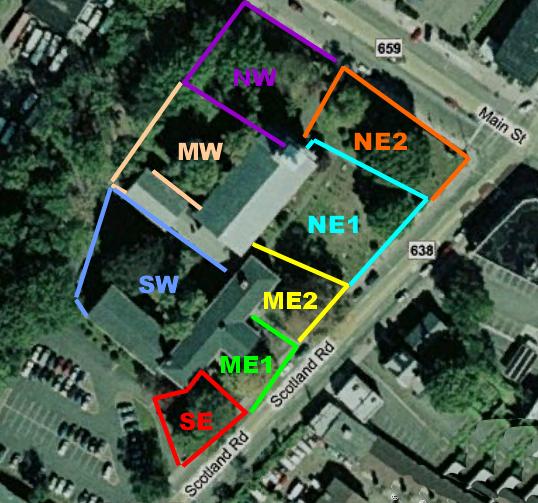
Mapping
the Old Burying Ground The mapping project of the Old Burying Ground began on 03/18/08. Mr. Robert Reed, historian from the First Presbyterian Church in Orange, NJ, met with me and gave me a tour of the grounds, plus access to the church archive records of grave stone inscriptions, old historical photos, and so on.I divided the Burying Ground into sections, as you see in this modified satellite photo. The Church is in the center of the plot. Mr. Reed explained that the church was built over the remains of settlers, but that their tombstones were moved to the outside areas. Thus, the stones may or may not mark the actual positions of the deceased's remains.I decided to begin mapping and cataloging from the South East Corner, nearest the parking lot, and map another section each time I return to the site over the next few months. |
|
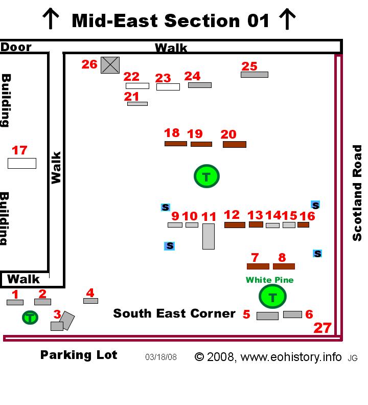
I began at the South East Corner (SE) and am currently working counter-clockwise around the Church.
Click on any of the section names above, or on the sections shown on the photo at the left to be taken to the Interactive map of that section. Asterisks show which sections are currently on-line. Other sections will come on-line as they are being mapped. |
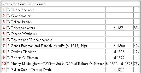
How to Navigate using the Interactive MapsModern headstones are made of marble (M), and are shown in white. Earlier stones were made of limestone (L), and these are shown in gray. The earliest stones are made of sandstone (S), shown in brown. In the Key, they are listed as S, L, or M.Beginning at the entrance from the parking lot, the stones were numbered from 1 to 26 in the South East Corner section. Each section will have its own separate numbers, beginning again at 1.The trees are marked with green circles for now. As spring begins to make them identifiable, I will add the variety of tree to the map, as I did for the White Pine in the lower right of the South East Corner section. |
 |
Construction of this Interactive Map is on-going
© 2008, James Gerrish and Frederick Goode, Temporary Custodians, www.eohistory.info